Banbury Civic Society ploughs into fight to protect historic farmland from industrial development


The society has fully backed residents of Nethercote and Keep Nethercote Rural Campaign in their bid to defend their countryside against a planning application for industrial estates over 160 acres of land across the M40 junction. The units would provide 24-hour storage and distribution.
The residents’ campaign was described in a Banbury Guardian story last week. The report described how an application, by speculative developers Greystoke CB for outline planning permission for the development, had been lodged with Cherwell District Council. The area is not included in the Local Plan, which is under review.
Advertisement
Advertisement
Banbury Civic Society’s leader, Rob Kinchin Smith said BCS has long-opposed any expansion of Banbury to the east of the M40 for landscape and heritage reasons.
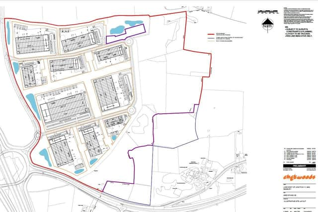
He said: “We are opposing this scheme for a mass of big sheds on Blacklocks Hill north of the A422 (from the A361 to the Cardus School), as well as another proposal that is coming forward for further big sheds south of the A422 that would cover the medieval strip fields and former deserted medieval village of Nethercote from the A422 to the Overthorpe Road.
“Whilst the applicant’s consultants claim in the Environmental Impact Assessment that there would be no significant environmental, heritage or landscape impacts arising from the Blacklocks Hill development, the landscape being judged to be of ‘low value’ (they say), we note that such a view is wholly at variance with Oxfordshire County Council’s Oxfordshire Historic Landscape Characterisation Project which includes an illustration, showing the landscape north and south of the A422 to be of “High Sensitivity to Urban Development”.
“The Society fully endorses the comments of the Inspector during the Inquiry on the Cherwell Local Plan 2031 when he said ‘Development of the land east of the A361, as noted in earlier landscape assessment work for the Council (2013), would have a significantly detrimental impact on the local landscape, intruding as it would into presently open countryside currently in agricultural use with inevitably large industrial and warehouse buildings. In particular, it would materially extend the built up area of Banbury to the east and lead to a significantly harmful erosion of its rural setting on this side of the town’.”